Fisheries Sensitivity Maps

What is it: 

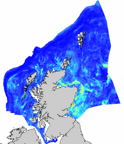
The Fisheries Sensitivity layers have been generated to identify the probability of presence of high abundances of 0-group fish (fish in the first year of their life) in Scottish waters. 13 species are covered by these layers. The work is explained in the Scottish Marine and Freshwater Science Vol 5 No 10 report 'Updating Fisheries Sensitivity Maps in British Waters' (see link in 'Data Sources' tab below).

These layers serve as an update of the existing (Coull et al., 1998) fish nursery maps also available on NMPi. The Coull et al., (1998) maps have been used for more than a decade to ensure that appropriate protection is afforded to sensitive areas from disturbance. These maps provided descriptions of spawning - where fish congregate to spawn - and "nursery areas" - areas where aggregations of juvenile fish can be found.

Zoom restricted as the model used to create the 2014 layers was designed for use at a regional level and above.

Date of data: 2014; Coull et al., (1998)

Links to Scotland's Marine Atlas: 
This information page is part of the theme: 
Fisheries sensitivity map - Copyright © Marine Scotland

Links and Resources

Map Type Click title for metadata and licence informationsort descending Date of data View Map
Marine Scotland Maps (NMPi) Layers (Dover) Sole - Modelled probability of year 0 group (restricted zoom) 2014-12-19 Access this map on NMPi
Marine Scotland Maps (NMPi) Layers (Dover) Sole - nursery grounds (Coull et al 1998) 1998-08-01 Access this map on NMPi
Marine Scotland Maps (NMPi) Layers (Dover) Sole - spawning grounds (Coull et al 1998) 1998-08-01 Access this map on NMPi
Marine Scotland Maps (NMPi) Layers Anglerfish - Modelled probability of year 0 group (restricted zoom) 2014-12-19 Access this map on NMPi
Marine Scotland Maps (NMPi) Layers Blue Whiting - Modelled probability of year 0 group (restricted zoom) 2014-12-19 Access this map on NMPi
Marine Scotland Maps (NMPi) Layers Blue Whiting - nursery grounds (Coull et al 1998) 1998-08-01 Access this map on NMPi
Marine Scotland Maps (NMPi) Layers Blue Whiting - spawning grounds (Coull et al 1998) 1998-08-01 Access this map on NMPi
Marine Scotland Maps (NMPi) Layers Cod - Modelled probability of year 0 group (restricted zoom) 2014-12-19 Access this map on NMPi
Marine Scotland Maps (NMPi) Layers Cod - nursery grounds (Coull et al 1998) 1998-08-01 Access this map on NMPi
Marine Scotland Maps (NMPi) Layers Cod - spawning grounds (Coull et al 1998) 1998-08-01 Access this map on NMPi
Marine Scotland Maps (NMPi) Layers Cod - spawning grounds - North Sea (Gonzalez-Irusta and Wright 2016) 2015-12-09 Access this map on NMPi
Marine Scotland Maps (NMPi) Layers Haddock - Modelled probability of year 0 group (restricted zoom) 2014-12-19 Access this map on NMPi
Marine Scotland Maps (NMPi) Layers Haddock - nursery grounds (Coull et al 1998) 1998-08-01 Access this map on NMPi
Marine Scotland Maps (NMPi) Layers Haddock - spawning grounds (Coull et al 1998) 1998-08-01 Access this map on NMPi
Marine Scotland Maps (NMPi) Layers Haddock - spawning grounds - North Sea (Gonzalez-Irusta and Wright 2016) 2016-11-13 Access this map on NMPi
Marine Scotland Maps (NMPi) Layers Haddock - spawning grounds - West of Scotland (Gonzalez-Irusta and Wright 2016) 2016-11-13 Access this map on NMPi
Marine Scotland Maps (NMPi) Layers Hake - Modelled probability of year 0 group (restricted zoom) 2014-12-19 Access this map on NMPi
Marine Scotland Maps (NMPi) Layers Herring - Modelled probability of year 0 group (restricted zoom) 2014-12-19 Access this map on NMPi
Marine Scotland Maps (NMPi) Layers Herring - nursery grounds (Coull et al 1998) 1998-08-01 Access this map on NMPi
Marine Scotland Maps (NMPi) Layers Herring - spawning grounds (Coull et al 1998) 1998-08-01 Access this map on NMPi
Marine Scotland Maps (NMPi) Layers Horse Mackerel - Modelled probability of year 0 group (restricted zoom) 2014-12-19 Access this map on NMPi
Marine Scotland Maps (NMPi) Layers Lemon Sole - nursery grounds (Coull et al 1998) 1998-08-01 Access this map on NMPi
Marine Scotland Maps (NMPi) Layers Lemon Sole - spawning grounds (Coull et al 1998) 1998-08-01 Access this map on NMPi
Marine Scotland Maps (NMPi) Layers Mackerel - Modelled probability of year 0 group (restricted zoom) 2014-12-19 Access this map on NMPi
Marine Scotland Maps (NMPi) Layers Mackerel - nursery grounds (Coull et al 1998) 1998-08-01 Access this map on NMPi

Pages

Type Title External link
Web link ICES