Strategic Surveys of Seabirds off the West Coast of Lewis
By 2020 the percentage of Scotland’s energy coming from renewable sources will increase. Studies have identified that there is a need to research how offshore renewable developments affect wildlife populations. The surveys available below will help to find out how one area of marine development, the west coast of Lewis, is used by waterbirds and marine mammals. Areas close to the Isle of Lewis have already been identified as being important for these groups of animals, through the Special Protection Areas (SPA) network.
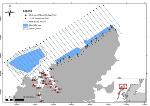
Methods used during these surveys included a desk-based study, a digital aerial survey and ground-based counts. The digital aerial survey involved an aircraft flying systematic 2km spaced transects through the survey area recording high definition video along four 200m strips thus achieving 10% sampling coverage of the area. The images recorded were processed, and bird and mammal species were identified by analysts post survey and strip transect analysis undertaken to derive abundance estimates for the study area. Density surface modelling was undertaken for fulmars, gannets and auk species. Ground-based counts involved an ornithologist undertaking a bird and marine mammal survey from 14 vantage points along the west coast of Lewis. These counts were co-ordinated as much as possible with the aerial survey, and were used to gain more information about more difficult to identify species, or undertaken in places known to be important for seabirds but likely to be missed by the aerial survey. A further vantage point study covering the majority of Loch Roag was also undertaken, covering areas outside the aerial survey study area.
The report and data can be downloaded by following the links in the table below.

Links and Resources
| Type | Title | External link |
|---|---|---|
| Web link | SNH - Birds | www.nature.scot |

