Fishing - Activity data and statistics

What is it: 

Data is collated about fishing activity in Scottish waters from a range of sources, including:

Links to Scotland's Marine Atlas: 
This information page is part of the theme: 
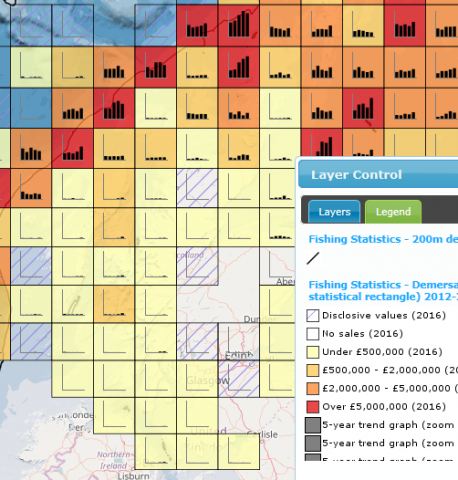
Demersal sales (£) from Scottish waters (per ICES statistcial rectangle) 20012-2016 © Marine Scotland

Links and Resources

Map Typesort descending Click title for metadata and licence information Date of data View Map
Map Layers (NMPi) Fishing effort (days) - pelagic active gear by rectangle- 2018-2022 2018-01-01 to 2022-12-31 Access this map on NMPi
Map Layers (NMPi) Inshore Fishing - ScotMap (2013) - Mackerel Lines - Number of Vessels 2013-08-26 Access this map on NMPi
Map Layers (NMPi) Fishing - Scottish Under 12m vessels - Creels, Pots and Traps - Annual average value (2017-2021) (£) 2017-01-01 to 2021-12-31 Access this map on NMPi
Map Layers (NMPi) VMS - Total hours fished by UK vessels >15m - all gears (2020) (MMO WMS) Access this map on NMPi
Map Layers (NMPi) Pelagic fish - Landed sales value (£) by rectangle 2018-2022 2018-01-01 to 2022-12-31 Access this map on NMPi
Map Layers (NMPi) Inshore Fishing - ScotMap (2013) - NOT Nephrops Trawls - Number of Vessels 2013-08-26 Access this map on NMPi
Map Layers (NMPi) VMS - Total value (£) of UK vessels >15m length - all gears (2020) (MMO WMS) Access this map on NMPi
Map Layers (NMPi) Fishing effort (days) - passive gear by rectangle - 2018-2022 2018-01-01 to 2022-12-31 Access this map on NMPi
Map Layers (NMPi) Inshore Fishing - ScotMap (2013) - Scallop Towed Dredges - Monetary Value (£) 2013-08-26 Access this map on NMPi
Map Layers (NMPi) Route Density (EMSA) Annual Totals - Fishing (EMODnet WMS) Access this map on NMPi
Map Layers (NMPi) Demersal fish - Landed weight (tonnes) by rectangle 2018-2022 2018-01-01 to 2023-12-31 Access this map on NMPi
Map Layers (NMPi) Inshore Fishing - ScotMap (2013) - Mackerel Lines - Monetary Value (£) 2013-08-26 Access this map on NMPi
Map Layers (NMPi) Vessel Density Annual Averages - Fishing (EMODnet WMS) Access this map on NMPi
Map Layers (NMPi) Shellfish - Landed sales value (£) by rectangle 2018-2022 2018-01-01 to 2022-12-31 Access this map on NMPi
Map Layers (NMPi) Inshore Fishing - ScotMap (2013) - Scallop Divers - Monetary Value (£) 2013-08-26 Access this map on NMPi
Map Layers (NMPi) VMS - Average intensity (hours) - Bottom trawls (OT) - 2010-2020 (ICES SR.2021.11) 2021-09-24 Access this map on NMPi
Map Layers (NMPi) Pelagic fish - Landed weight (tonnes) by rectangle 2018-2022 2018-01-01 to 2022-12-31 Access this map on NMPi
Map Layers (NMPi) Inshore Fishing - ScotMap (2013) - Scallop Towed Dredges - Number of Vessels 2013-08-26 Access this map on NMPi
Map Layers (NMPi) VMS - Average intensity (hours) - Nephrops and crustaceans with bottom trawls (OT CRU) - 2010-2020 (ICES SR.2021.11) 2021-09-24 Access this map on NMPi
Map Layers (NMPi) Shellfish - Landed weight (tonnes) by rectangle 2018-2022 2018-01-01 to 2022-12-31 Access this map on NMPi
Map Layers (NMPi) Inshore Fishing - ScotMap (2013) - NOT Nephrops Trawls - Monetary Value (£) 2013-08-26 Access this map on NMPi
Map Layers (NMPi) VMS - Average intensity (hours) - Dredges (DRB MOL) - 2010-2020 (ICES SR.2021.11) 2021-09-24 Access this map on NMPi
Map Layers (NMPi) Sea Fisheries Statistics - Districts (2013 onwards) 2013-01-01 Access this map on NMPi
Map Layers (NMPi) Inshore Fishing - ScotMap (2013) - Relative Value (£) 2013-08-26 Access this map on NMPi
Map Layers (NMPi) VMS - UK activity associated with Oil and Gas Pipelines (2007-2015) - Nephrops Trawls 2017-07-19 Access this map on NMPi

Pages